Mars Structures: Theory on falling water table and structure fabrication in meteor impact craters
The Mars mission revealed a number of structures on the surface of Mars.
Prof. Alfred McEwen had some interesting images, and more will be released shortly.
This goes into some discussion on why the structures are located in the meteor holes. What it might have been like: [ Click ]
There is more analysis of other Mars images using Google Mars [ here]
Constant's Theory of Falling Martian Water Table
The photographed Mars structures were located within the meteor/asteroid-impact craters because of water problems. Constant theorizes that the water table was falling, and easier for the intelligent life to access water at the bottom of the craters.
Notice the winds are higher on the surface, covering structures. It appears the winds picked up well after the structures were constructed in the impact craters, and wind protection was not originally intended, but a by-product.
Structure size and hallway width also give us indications of the size of the intelligent life.
Comparison of Martian structures to Iranian dwellings. [ Click ]
Contant's Theory of Martian Aquifers
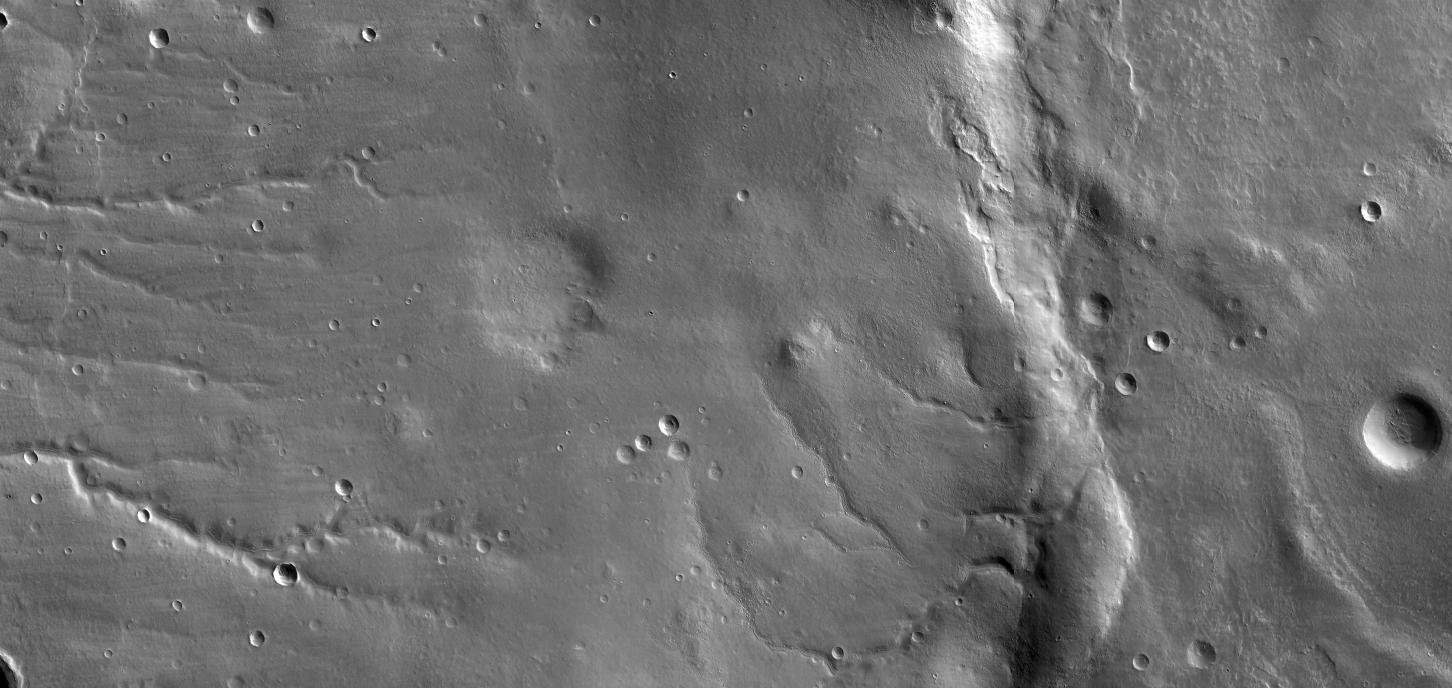
This image has many numbers on it. If you look at the image as a single snapshot -- and zoom out, and not zoom in -- you'll notice something: You can connect the numbers with horizontal lines. If you zoom in, you'll notice that the lines you've drawn are roughly over some of the unusual terrain patterns.
One important thing to note is the order of the events. Look broadly at the image, and you'll see that the river beds extending from the ridge line to the right are overlaid with asteroid impacts. This indicates that the river bed existed first, then dried up, and the asteroids hit second; then the dwellings were created at the bottom of the asteroid impacts.
This suggests that the water was already running low, was seeping into the ground quickly after thermal conditions, and was insufficient to maintain the water flow in the riverbed. However, the dwellings were created well after the asteroids impacted indicating that the water which formed the original tributaries was already falling, and well below the surface.
Constant theorizes that the structures at the yellow numbers were built along the Martian Aquifers, and that the water on the surface was sufficiently thin to non-existent that the inhabitants had no fear that their dwellings -- along the surface canals and inside the asteroid craters -- would get flooded.
The key would be to look for where original dwellings were located, and look for signs of a population movement -- from regions with higher elevations on Mars, above the Martian Seas -- to these lower lying areas. If there is DNA on the surface, and if this theory has any merit we should be able to map the population movement using this aquifer theory.
Using Google maps of Mars we can compare the images of Mars in this page which is listed here and here to look for the likely population movements.
In other words, let's assume the population centers are where we find them; and assume that they moved from higher elevations. We can work backwards and move along the likely travel routes from higher regions [to be determined] and get an idea of where they came from.
Based on the geology, we can also make some estimates as to how old the surface structures are, not only in their final location, but along the routes. Based on this migration theory, this can give us some idea of the speed of the population movement, and act as a check on our estimates of how quickly the water was falling.
Where is this image on Mars
The JPL image is "one click" to the left/west of Ruza Crater. [A "click" is the click on the Google mars Maps -- click on the left arrow once, and you'll see a familiar formation. [I just saved you two days worth of work.]
What would be nice is if the Mars image coordinates for each image were integrated with the Google Mars Maps; that way we could make some informed judgments as to target areas, make some predictions where the population centers were most likely located, then backtrack to these locations, and find new Target areas for JPL.
At this juncture it's unclear [a] where to get the coordinates from JPL; [b] how to input these into the Google Map; and [c] how the final images of the dwellings fit on the Google Maps.
It would be nice if there was an XML-RSS data feed back and forth between Google and JPL for the following:
In the future, I would anticipate people will be interested in the following types of information, and an equally impressive integration between JPL and Google XML feeds so that we could do some mapping, research, and forecasting:
What could be done is using some clustering analysis is come up with some theoretical population sizes, and forecast the total mass of energy required to sustain this population. This approach has already been discussed here: [ Click ]
Instructions: Next steps: Google Mars at AZ U Click [ Sample coordinates ]
Here are the coordinates: Click
Martian Longitude: -40.6 degrees
Martian Latitude: 303 degrees East
[ Valid Google Map: Sample coordinates
[ Sample coordinates
Tested images: Unclear why the coordinates aren't matching [ 303/-40.6 ] vs. the [ -33, 55 ] in image B below:
A. Google Maps: CLick
B. Enterprise image: Click
The easiest way to find things on Google Mars maps is to take the names of the craters off the Enterprise Images, and plug them into Google Maps, ex: Bunge
The problem is, though it's hard to tell which crater to look at -- it would be nice if Google Maps could highlight the actual object, that way I'd know where to zoom in. At this point, I can't determine:
Getting familiar with Mars and the JPL image.
There's a fast way to find out where you are on Mars: Think of Mars as a bunch of constellations: Each of the craters forms patterns like stars.
What you want to do is look at the links below, then zoom out; keep all the versions open and skip back and forth. You'll start to see how the different points relate to each other on Mars. Practice zooming in and out; and scrolling the image box. In no time you'll have a sense of where the things are, even though you can't see them in your screen.
Here's how:
Step 1: Look at this image: [ CLick ]
Step 2: Notice the yellow box: To the upper left of that is Bosporos Planum
Step 3: Notice the yellow box: To the lower right is Argyre Planitia
Step 4: Look for the three volcano-like-mountains in a line -- imagine that being a single line -- draw a line through the three volcanoes -- make a perpendicular line to that, extending to the lower right -- you'll the Ruza crater
For purposes of this JPL test image, Ruza is one of the key places.
The other location is the Tabor Crater. I'll show you hw to find that.
The key is to notice the relative distances between Tabor and Ruza in the Google Map.
Here's how to find the ridge line in the JPL photo: [Click ] Notice the yellow box [assuming that's the image] is about halfway between the Ruza ridge line and that Tabor Crater.
Task: How to find objects on the JPL images, even though you can't read the images.
The way to manually scroll and find the numbers: Jump back and forth between the two images
Step 1. Keep three versions open:
A. The numbered version in a single shot, the numbers will be small; [ click ]
B. the single frame version; and [ Click ]
C. the numbered version zoomed in, to read the numbers [ Click ]
Step 2. Look for your desired area; notice the location of the area of interest in terms of X- and y-axis; these will be the location to scroll on the zoomed-in version; Find the equivalent distance along the single frame
Step 3. Scroll until the browser window-toggle-bars match that distance on the single frame: Then you will arrive at your desired number.
Step 4: Then you can change the number manually to see the images:
A. Three digits:
Sample: http://www.mroimages.com/156.html
Generic [Change XXX to your number]: http://www.mroimages.com/XXX.html
B. Two digits:
Sample: http://www.mroimages.com/67.html
Generic [Change XX to your number]: http://www.mroimages.com/XX.html
C. Single Digit:
Sample: http://www.mroimages.com/06.html
Generic Change X to your number: http://www.mroimages.com/0X.html
Task: Sample Calibration between JPL images and Google Mars Maps
Here's the match
1. Task: How to find the numbers and craters in the JPL images as they related to the Google Mars Maps images.
2. Images
A. Photo: [Click ]
B. Map on Infrared: [Google Mars Map ] -- The reference crater within the circular opening is about 100KM west of Ruza.
3. Calibration: Confirm the following points:
- A. "Far Right Crater": Far right, halfway down, Right of circle ridge line [ Points 156, 160, 166]
- B. "Opening": Opening on the ridge line, to the left of the crater at 156 [ opening is just south west of points 153, 165 ]
- C. "Center shaded area": Horizontal from far right crater: The left shaded region [ Point 67 ]
Check the Far Right Image on Google Maps, it is halfway between the top and bottom of your browser. You will see three numbers.
The three numbers on the far right crater -- the reference point in the circular shape in Google Maps, has the following three numbers:
156 Click
160 Click
166 Click
Compare the above to Iran [ Click ]
Center shaded area at 67: Click
They're going to need some really good navigational aids when they start flying on Mars -- this visual-stuff isn't going to work. Far too easy to get lost. Would be nice if there was a satellite array that permitted GPS-tracking, and then some land-based navigational aids. It's going to get far too easy to get lost. They're going to have to have a quick method of getting ground-based-voice-support: Something that will have real people guiding the various aerospace vehicles across Mars. Something that will quickly set-up, and assist real time within a matter of seconds.
What if the dwellings were created in a desert; and there was water to the east in Argyre. If this was true, then we would expect to find on the southern mountains [3 Clicks south of Ruza] various dwellings.
If the above discussion is valid, we would expect to see along these travel routes into the Argyre, hill like structures, especially on the southern rim like this. Would not be surprised to see along the Argyre images like this.
It's not clear what level the sea was; but it looks as though -- if there were travel routs from the test image to the Argyre -- on the assumption that they were going to low lying areas where there was more water -- the issue would be which route would they travel to and from these remote outposts near Ruza.
The most likely travel routes would follow the types of patterns we'd see on Earth: Namely, people would move to minimize their elevation change. I think they'd travel through the canyons, to the south of this crater [1 click south of Ruza]. We would expect to see abandoned equipment along this travel route.
Notice at the 10-o'clock position on this crater: There is relatively low-lying area at the ridge. This would suggest that if this was a dwelling area that the entry-exit point from the crater would be at this position. Namely, we would expect to see some sort of indication of high traffic through this region, while immediately adjacent to these trails, there would be no abandoned property. The problem with this assumption is that the ridge line from the crater base is very steep; if they had land-based vehicles they'd be more likely to travel along the ridge, and enter-exit at the 3 o'clock position, through the canyon. If they traveled up the canyon wall, I'd expect to see diagonal lines following in a conical shape to gradually rise, as opposed to a straight line up the side of the canyon.
The other issue is the fabrication facilities for the equipment and other machine tools. I would expect there to be a system of trade or travel from the more heavily populated areas around Argyre where the water would have been captured.
Also have been considering whether by physical design one could analyze their political associations, economy, and other cultural things.
Let's consider that these objects are from a culture in a land that from the air appears no different than Mars.
Be interesting to compare the Google Mars Maps with the Google Earth Maps of Iran.
Here's a sample of Farumad and an index for other cities listed in the Chicago images from the 1930s. [ Index ]
Image of Iran: Farumad
Farumad, Iran
Google Map
Notice this image: It has a cliff, very similar to the large cliff in the Mars JPL image, to the west of Ruza Click
Notice this image: The shadows -- we're not seeing many shadows on the Mars Images. That would help with height, and give us an idea if the strctures were walls.
Notice this image -- gardens -- and how they compare with the structures in the craters. It's possible that the craters weren't actually buildings, but where food was grown. A close-up version of these formations may reveal something like this.
We judge these are the likely images which will be used for comparison when the Mars Orbiter zooms into the face of mars, and the surrounding palace-like structures. [ Click ] Here is a sample diagram that will likely be used as a comparison. Also, these are the likely forecasted structures -- pillars, and a great walkway -- that will be asserted to exist on Mars in the open area.
It is likely that there will be efforts to look at the debris, and reverse-engineer the possible images on the sides of walls. It remains to be seen whether the orbiter can be positioned to look at objects from an angle; if this is possible, there may be a way to look at the side of the buildings to see if there are visible drawings, or other writing.
There will likely be three-dimensional renderings of the Martian landscape, and the final results should not expected to be surprising, and may very well look something like this. At this point, we can only speculate what the details might look like. We fully expect to see architecture that is similar to these columns. What is curious, is there are no shadows similar to these columns in the remote craters.
We fully expect to see in the central areas steps and large structures as are depicted click. Also, we fully expect the researchers to joke that, "After a while, we started to mix up the Mars and Earth images and couldn't tell the difference," as here.
For there to be facilities inside the craters, the asteroids would have penetrated the Martian atmosphere, suggesting the craters were formed in the absence of an atmosphere raising the question as to what the Martians were breathing.
There appears to be an answer. Mars images have no obvious sign of roads. Clearly the roads may have been covered with blowing debris, but even on the infrared there's nothing visible.
Yet, the objects in the craters appear similar, suggesting not only a common training and oversight system for fabrication and maintenance, but that the way to move between the craters may be underground tunnels. The structures at the surface could be filtering systems or airlocks.
The obvious problem with this theory -- that there were no roads, therefore there must have been tunnels -- is the obvious contradiction: The riverbeds could very well have been roads.
posted by Constant @ 9:14 PM
![]()
![]()


<< Home