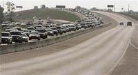
Rita: What's wrong with this picture?
They said they "learned their lesson" from Katrina. I'm not convinced.
There's some strange stuff going on.
 First, why aren't both lanes open north?
Second, why is information about the strange Rita movement getting
For example, there are two versions of Advisory 21.
Version 1; and
Version 2
Note the images have the same time and location; the only difference is the second version adds the rain which falls right on the New Orleans levees.
I've been tracking these Rita charts since Tuesday, and have noticed something weird: The actual path is slightly north and to the east of the forecasted tracks. however, the forecasted land falls continue to "not reflect" this deviation.
For more discussion/details on these Rita charts, scroll halfway down this blog-entry here.
1. The changes in Advisory 21;
2. Rita traveling further north and east than originally forecasted, but the locations where Rita was forecast to hit/make landfall doesn't reflect this adjustment; and
3. Does someone not want others to know that:
[a] Rita's actual track is trending more north and east than originally forecast;
[b] that the forecasted land fall location isn't changing despite this deviation from the originanl forecast; or
[c] if you include the likely Rita destruction with this more north/east tracke, the proposed "scope of the Katrina recovery" effort is likely larger than what the RNC is proposing to use as a baseline for budget cuts?
It sure seems strange that the forecasts aren't making sense; and that discussion about these quirks are getting deleted.
Anyone else noticing anything strange with Rita forecasts, storm tracks, discussion, or commentary about the public forecasts?
Update
Comment found/still available: September 22 2005 08:44 PM.
1,000 apologies for the false alarm.


<< Home