N. Korea: Where's the water?
 Summary
This note concluds that a NoDong missile exploded at 41 N 127 E. The North Korean explanation for the explosion does not add up.
 Discussion
News: They said in N. Korea that the explosion was related to preparations for a dam.
Challenges:
Let's guess
Step 1: Explain inconsistencies in the names.
The names are interchangeable. "Ryanggang (full name Ryanggang-do) is a province of North Korea. The province's name is sometimes also spelled as Yanggang in English." Ref
This means the following two references are actually talking about the same location:
Yonhap reported that a mushroom cloud up to 4 km (2.5 miles) in diameter was spotted after the blast in remote Yanggang province in the country's far northeast. Ref
part of a construction project to build a hydro-electric dam in the remote mountainous region of Ryanggang on the Chinese borderref
Step 2: Exclude rivers from the possible pool of locations.
The location of the explosion was not on the border with China, but inside Korea. This means that the site was not on the Yalu or Tumen rivers running east-west between Korea and China.
"The cloud and seismic tremors were traced to a location in Kimhongjik County, about 32 kilometers, or 20 miles from the Chinese border" ref
This location also closely matches the location mentioned in the BBC:
The United States and South Korea had already played down suggestions that the explosion, near Yongjo-ri in Yanggang Province, was caused by a nuclear device. Ref
It looks as though the recurring name is "Yanggang", which is in north-central North Korea, not North East Korea.
Primary assumption on location
Therefore, I conclude the approximate, although unverified location, coordinates are 41 N 127 E. Map; alternate.
Step 3: Other possible locations
Let's consider some other possibilities to test the primary assumption. There is some inconsistency between the names in the news and the described location in Korea. The referred-to names are in North-central Korea, but the media describes these locations in north-east North Korea.
Version A: References to a region in north-east N. Korea "Yonhap reported that a mushroom cloud up to 4 km (2.5 miles) in diameter was spotted after the blast in remote Yanggang province in the country's far northeast". Ref
Version B: Presumed "explosion site name" corresponds to a city in Central N. Korea : "...part of a construction project to build a hydro-electric dam in the remote mountainous region of Ryanggang on the Chinese border ... " ref
Version C, a location not consistent with the seismic reports. "Rodong missile bases are located in the blast area, and extremely explosive liquid fuel, which is also very flammable, is used in production and in operation of missiles," Kim said. "I believe it was a mere accident triggered by mishandling." ref
For purpose of clarity, I'm assuming "Rodong" is the same as, Oryu-dong, in the south west of north Korea.
In re version C, The location is much farther that 25 KM from the Chinese border.
The explosion could have been a missile mishap; but there would have to be a better explanation why an exploration occurred at this location, while the sensors indicated the problem was within 25KM of the Chinese border.
Also, note that this south-west location does not match the media report that the explosion occurred in the north-east.
If the explosion was in north east North Korea, there's a simple problem. In 1997, CNN reported that they were having a drought in this region; and this problem was still reported in 2001.
I hear of no new miracle that both created water, and reversed the cyclical lack of rainfall problem. In other words, the problem isn't simply that there's a drought, but that there's been no change in the weather to justify thinking the "drought problem" is over, or that it makes economic sense to construct a dam in NE Korea. They don't have enough water in the existing dams, why are they making more dams on rivers that are also dry or have a questionable supply of water?
Step 4: Other failure modes
After testing the alternative geography-options, let's consider other theories besides a dam or a missile mishap. There is another theory on what caused the problem:
South Korean media also said that an accident at an underground munitions depot or a weapons factory was a likely explanation for possibly two blasts Ref
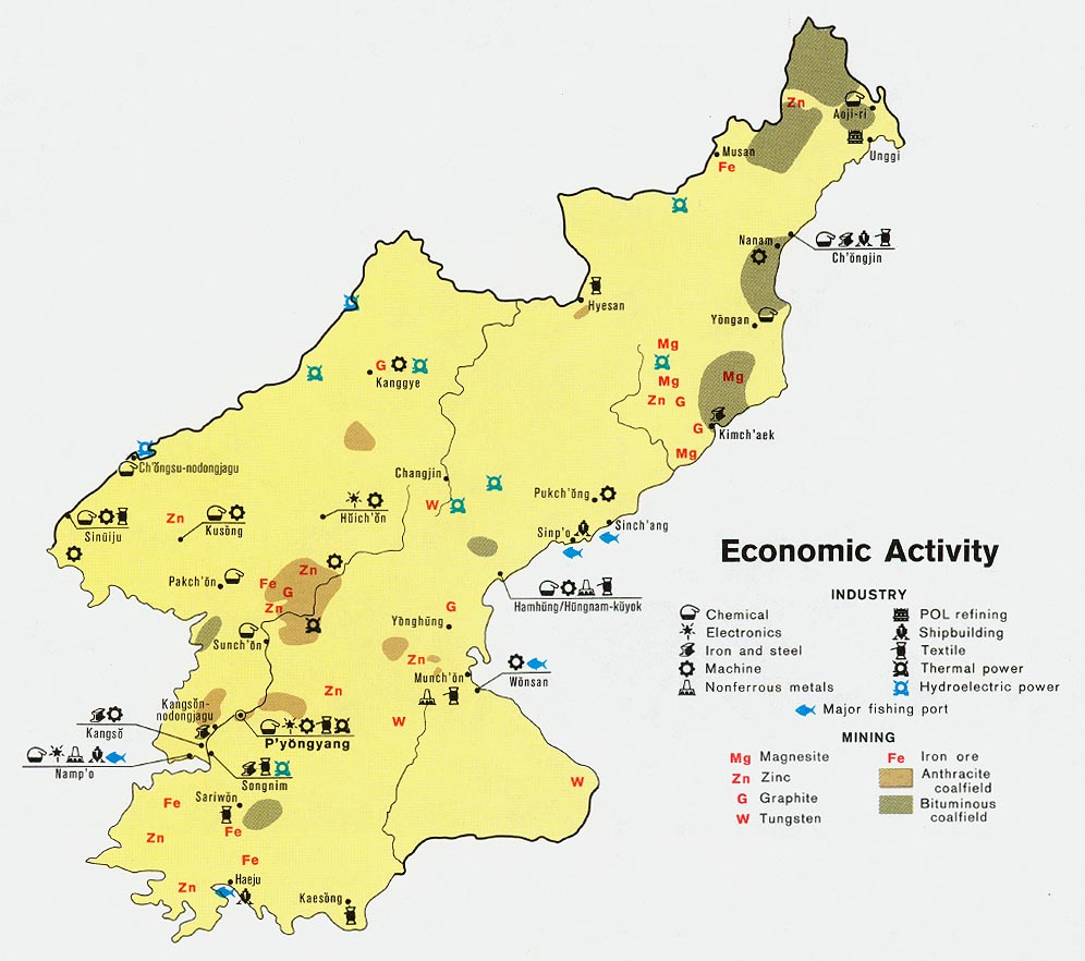
One could argue that this theory is problematic in that the current maps do not show military installations in north-central Korea that are associated with munitions storage; nor with any facilities that would house, maintain, offload, or transport munitions of the size required to create a mushroom cloud 2-4 KM wide.
However, there is one base that meets the requirement of 25km within China's border: That is Yong-jo which is where the NoDong missile is deployed. It would not be surprising why a missile that is not well understood in the West might explode leaving an unusual cloud-burst.
Adding credence to this theory is the Telegraph report that the explosion occurred near a secret missile base. Ref
Clearly, the United States [from Step 3 above] has already stated that there was nothing going on at Yonjin. However, consider what was stated in 1998:
at a News Briefing on 09 July 1998 Secretary of Defense William Cohen states that "What we can say is that North Korea has completed its development of the No-dong missile, but I am not in a position to comment in terms of when or where or how there has been a deployment of the missile itself."
The US cannot acknowledge publicly what it already knows. This is the magic of plausible denial. Note also that the US didn't deny that a missile exploded; it merely stated that there was no nuclear event--both these support the contention that the event was related to a missile mishap.
If this is not actually the case, then we have a larger problem. This means that existing intelligence and open source from Korea has not been able to track, monitor, or identify a facility that could house such munitions. In short, the "problematic intelligence gathering" problem [not knowing things in Iraq and assuming the worst; or knowing things and it not getting acted on in re 9-11] continues.
The double-language of Powell's statement [denying a nuclear event, but leaving open the option that a missile exploded] appears to suggest the US is fairly certain of the location, and origin of the explosion. It remains to be seen "what the visitors report after their 'open' visit to the 'site'.
If this is not the case, then the US currently runs the risk of making the same error, especially at a time when the intelligence community is not only being re-organized, but it is being flooded with "terror-related" information. Thus, I assume the likely assumption is going to be driven once again by policy, thereby repeating the error made in Iraq; and there is also the chance that the available data [however convoluted] will be interpreted based on our assumptions of how we would approach the issues, not in how the North Koreans are approaching the issue.
If these convoluted problems are continuing despite both the catalyst of 9-11 and the reorganized intelligence community, then we have a much larger problem on our hand than "what is making dust clouds in North Korea." I would not presume the same intelligence community that correctly reported to the DSP the existence of the Phoenix Memo [and was blamed not just in re 9-11 but also in re the OSP manipulations] is going to remain quiet. I think the President knows exactly what "most likely" occurred and will say nothing, even if the North Koreans take the visitors to the wrong location.
Step 5: Review the maps, and identify any inconsistencies.
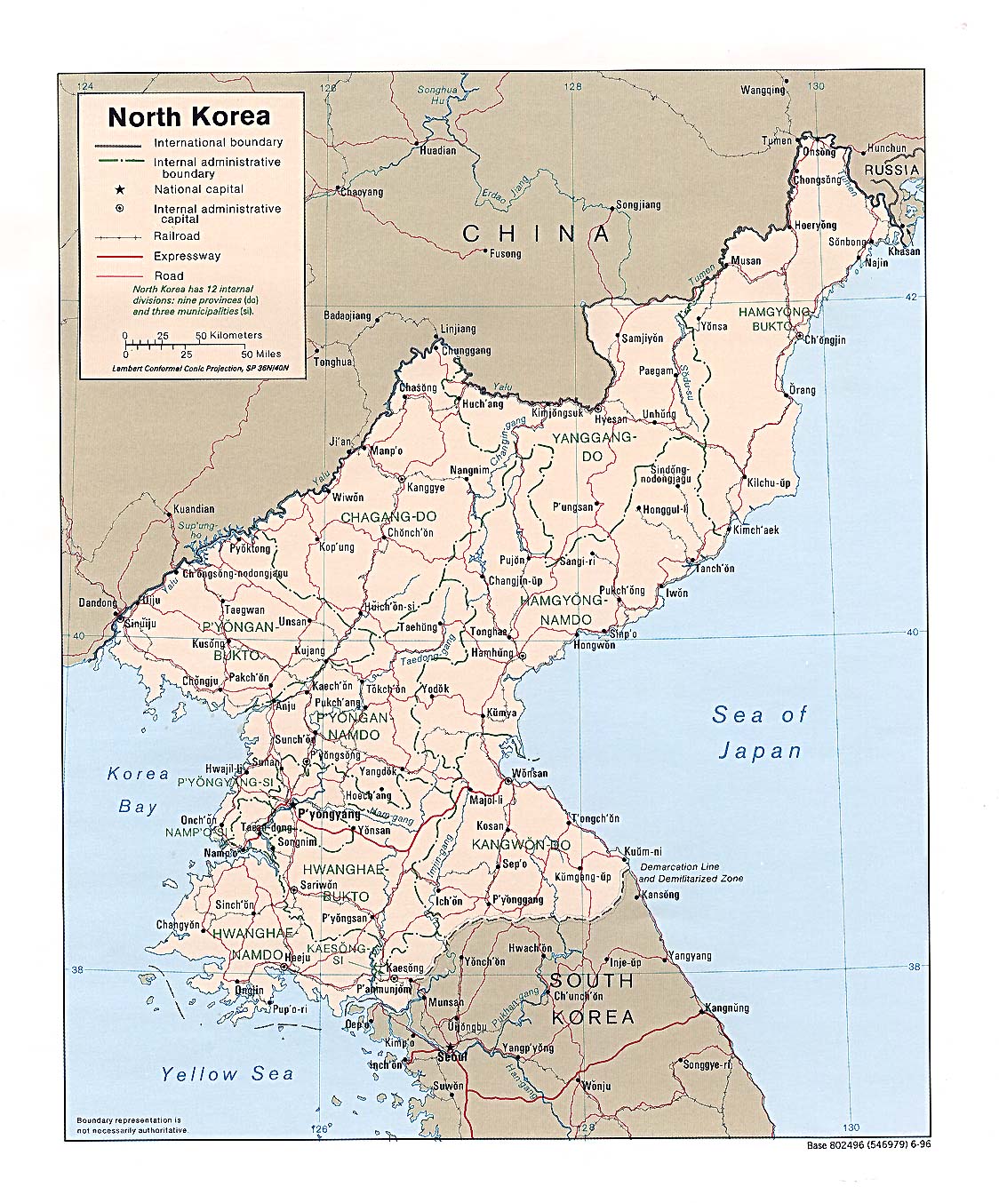
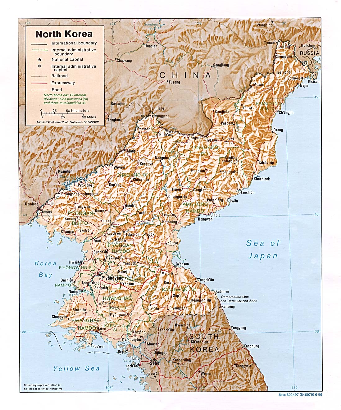
Let's consider the details in the maps and compare the locations with the names provided. On this map, Yanggang province is not listed in the upper north east; however, a Yanggangdo is listed in north-central Korea. Notice that Kimjongsuk is just east of Hysan in the Yanggangdo province.
Step 6: Test the alternate theories against the maps.
The alternate hyothesis is to assert, "The available maps do not show a military storage location just east or south of Hysan." This is not supported by the data. Ref Cities nearby. military sites.
Step 7: Cross check the dismissed theory against the dismissed data.
This step re-incorporates the dismissed assumptions about the location, and combines them with the dismissed failure mode. The goal of this step is to re-compare that we assume is not plausible and identify whether there is any possibility these assumed-impossibilities could actually occur.
Supposing the explosion actually occurred in the North-east corner of North Korea, there is little to persuade one that there is a plentiful water supply in NE N. Korea to justify building a hydro plant. In fact, Korea has the same problem in North-central region just east of Hyesong.
Pause
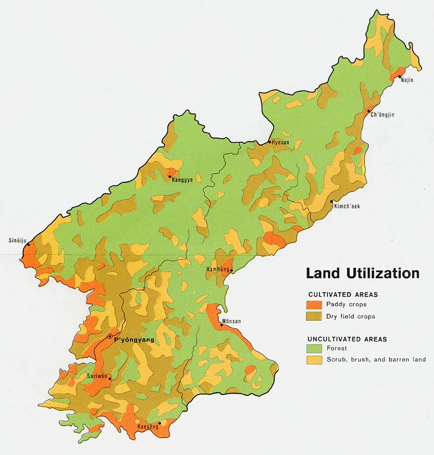
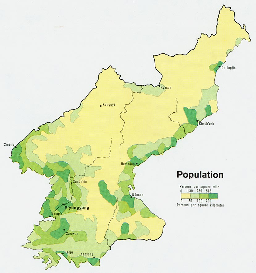
Uh, OK. Why isn't there any water nearby? Vegetation map in the far north suggests there is inadequate water supply. hydro sites; if you compare the hydro locations [old map] to the population centers, it's not clear that an explosion 20 miles within the Chinese border would be related to a hydro plant--there's no water, nor a population center. To the far north, there's no vegetation, meaning there's no water to divert. In other words, I'm not seeing either the water supply to divert, nor the population center to justify that diversion.
the relatively small Huchang river in the area made it an unlikely and unfeasible site for a major hydro power plantRef
There is very little vegetation just east and south of Hyeson, the most probable location of the explosion.
Step 8 Dove-tail the current theories with what is publicly known.
This is called, "Doing a sanity check on the recent media to see if we concluded anything at odds with current events." Note that international inspectors had recently visited North Korea:
UNEP chief Klaus Toepfer called on the international community to support the Pyongyang Government's efforts to safeguard natural resources. "We must respond so it can meet development goals in a sustainable manner," he said. Ref
The challenge is to explain why the apparent momentum coming out of the UN visit and Toepfer's statements, that the North Koreans would suddenly say, "Despite the world community recognizing we need help, we're not going to build on that momentum, and proceed on our own on this development project." Ref
The Article continues, " ... Mr. Toepfer and the head of the DPRK delegation, Ri Hung signed a framework agreement to guide joint activities that will further strengthen capacity for environmental protection..." Ref
Let's not pretend that agreements to cooperate suddenly mean something; they are worthless in the United States when US firms and governments know there are meaningless consequences for infractions.
The point is not that they are secretive and unreliable [this is already known]; but that despite them opening up, they take "action on a dam" that is both out of the blue, and at the same time unrelated to any proven sources of water.
If North Korea truly was working on a dam [despite the problems with drought, pollution] now would be the time to build off the momentum of the UN visit and say, "These are our plans; this is what we need help with."
Analysis
Notice the hydro plans are roughly located near population centers. Putting aside the problem of outdated maps, notice the assumed location of the explosion is not near a major population center, nor near any hydro plants. Which begs the question: Why build a hydro-plant so far in-land: The further the hydro plant is from the consumer, the more costly the power and they greater the power loss.
The Hu-Chang river is not a major body of water, it's little more than a stream that strectches a mere 36km before it dries up, and it's only 5m across at its widest end, and only about 1m deep, and it makes no sense why anyone would want to build a large dam here. Ref
Other locations along the rivers for a hydro plant are more economic; they have plenty of other rivers near population centers to build hydro plants. Ref
Korea's economic growth rates do not justify both a new hydro plant in a location so far away from population centers. Further, we're not hearing a "great leap in their economy" that would require power or electricity [power outrages are not news]. Notice that the military-related facilities and industrial production sites are no where near this location.
Even if there is a hydroplant, why build a hydro plant south of a location where there is a problem with inadequate water? This is the worst location to build a hydro plant: There's inadequate water [relative to other locations], and it would make more sense to put another hydro plant along an existing proven source of water.
Bluntly, there's little evidence there's water, much less a flowing river, near the explosion site.
Notice these questions suffer from the "what would we do-respond" syndrome [which explained why we ignored India's claim they were actually going to test a nuclear weapon], not what is necessarily going on or what they are doing. |
Other views:
Farm electricity-water demands: Problematic view
There is a drought, and they are short of electricity. Quote refs. More
However, if there's a drought, what good will having hydro dams be? The only way a dam will solve the electricity problem is if there's water; inadequately electricity isn't solved by building dams in places with unreliable water supplies; and if there's plenty of water [to create electricity], there's no need to have electric pumps to pump out the water.
Future research
What's needed is a map that overlays the following: [1] The current water supplies/rivers; [2] the site of the existing hydro-electric dams; and [3] the site of the explosion, to answer:
- Does the water supply justify building dams? - What location is the most effective dam-location to address North Korea's energy demands? - Why were the "other locations" not used? - Do the electricity-demand vs water-supply levels justify building new dams [a] in any region; and/or in [b] this region? - What signal is North Korea getting that, despite recent cooperation and agreements to assist North Korea, that North Korea needs to move on its own on major energy-development programs? There is the possibility that the location shown ["visit"] may not match the location where the explosion occurred ["explosion site"]. - Is the amount of dirt that [a] has apparently been removed at the visit site consistent with [b] the size of a proposed dam? - Is the size of [a] the hole [at the visit site] consistent with [b] the seismic measurements [at the presumed explosion site]? - Is there any evidence during the visit that vehicles have moved earth to create the hole in the ground? - Is there any evidence in the weeks prior that a crew has moved this dirt from the visit location to another location? [Review satellite imagery to detect convoys of trucks and/or fuel movement to support this effort] - Are there any restrictions on [a] traveling to possible locations where vehicles may have taken the dirt; or [b] physically traveling down roads where large convoys may have moved the earth? - If a NoDong missile were to explode, how much earth would it move, and what kind of debris pattern would be left behind? - Is the amount of dirt that was moved in the explosion consistent with the site visit; or must there be a third location nearby where the actual NoDong missile exploded? It is possible that the site visit may be to another location other than where either [a] the presumed dam is being created or [b] where the assumed-missile exploded. - What effort will be made to ensure the following three physical locations are understood: The site of the missile explosion; the site of the visit; and the site of the possible dam? - How is it determined that the assumed-missile explosion site is actually where the visit occurs? - What subsequent efforts are made to further "dig more holes" for the dam? [One explosion of this magnitude is generally not enough] |
posted by Constant @ 2:33 PM
![]()
![]()


<< Home